Turn your data into answers on a map
Upload files, add map services or connect a database. Ask questions in plain language or SQL, then share the result with anyone.
Ask a question in plain language and get the answer as a layer on your map.
Layers, basemaps, filters and popups, styled in the browser.
Connect Postgres/PostGIS, SedonaDB over GeoParquet on S3, or ArcGIS, WMS and OGC API services.



Gallery
Explore maps with their data and method
Each map lists where its data comes from and under which licence, and opens in GISOwl as it was published.
-
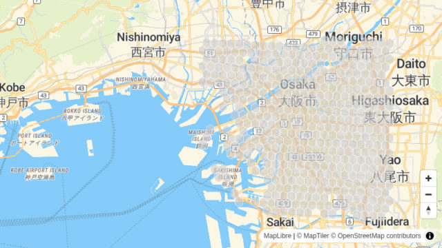
Demonstration
Where shops concentrate in Osaka, by H3 cell
Osaka
440 H3 cells with shops
Geospatial Analytics -
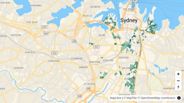
Demonstration
Where Sydney's planning control allows eight storeys or more
Sydney
880 properties where 8 storeys or more are allowed
Real Estate -
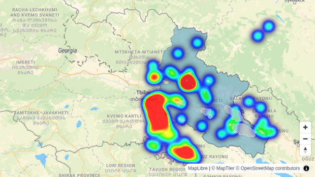
Demonstration
Farmland of 20 ha or more within 2 km of a substation, Kakheti
Kakheti, Georgia
49 farmland blocks of 20 ha or more within 2 km of a substation
Energy and Utilities
One price per workspace
Starter
$31 /mo
$372/yr billed annually · save 21%
For small teams publishing maps and asking Ask AI every month.
- 1,500 Credits a month
- 3 seats
- 50 GB storage
Growth
$95 /mo
$1,140/yr billed annually · save 20%
For teams importing and analysing large areas.
- 10,000 Credits a month
- 5 seats
- 200 GB storage
Scale
Custom
Custom pricing and limits for organisations.
- Unlimited Credits
- Unlimited seats
- Unlimited storage
Trusted by teams worldwide
Loading…
Share the map and keep working on it
Charts, comments, exports and field data, all on the same map.
Add statistics, bar charts, histograms, time series and filter sliders to a layer's legend, or swipe between two layers to compare them.
Invite viewers, commenters and editors, share a link or embed the map on your site, and discuss it in comments pinned to the map. Export the map to QGIS, or export layers to GeoJSON and CSV, and to Shapefile, GeoPackage, KML or DXF on paid plans.
Record GPS tracks and geotagged photos on iPhone. The app keeps working offline and sends everything to your map once it has signal.
Draw, style and group notes and shapes on the map, then turn them into a layer or export them as GeoJSON.
Loved by teams worldwide.
GISOwl makes mapping so intuitive that teams never want to go back to desktop GIS.
Loading…
Examples by industry
-
 Agriculture
Compare crop area between seasons, region by region.
-
 Cities and Government
Answer planning questions with your council's own published layers.
-
 Climate and Natural Resources
Map maritime jurisdiction, from territorial seas to EEZs and overlapping claims.
-
 Education
Teach spatial SQL with queries whose answer appears on a map.
-
 Energy and Utilities
Screen land near substations and outside protected areas.
-
 Engineering and Infrastructure
Count the buildings and assets inside a route corridor.
-
 Geospatial Analytics
Aggregate point data to H3 cells and share the map.
-
 Insurance
Count properties inside a hazard footprint and map them by H3 cell.
-
 Real Estate
Find the properties where planning controls allow eight storeys or more.
-
 Retail
Find the homes with no supermarket within 1 km.
-
 Telecom
Find the postcodes where fewer than half of premises can get gigabit broadband.
-
 Transportation
Find the homes more than 400 m from a bus stop.

Connections
Query your data where it lives
Connect PostgreSQL with PostGIS or GeoParquet on S3, or add ArcGIS and OGC services by URL or from the Data Hub. Query them with SQL or Ask AI: each result becomes a layer on your map, and the source stays read-only.
-
 PostgreSQL + PostGIS
-
 GeoParquet on S3
-
 ArcGIS services
-
 Feature services
-
 Map tile services
-
 STAC catalogues